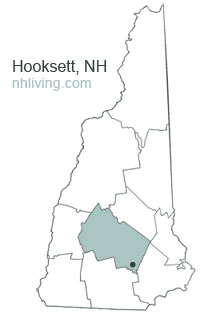
Hooksett, New Hampshire 03106
Hooksett, NH Lodging, Real Estate, Travel & Visitor Information

![]() The town of Hooksett, New Hampshire was first known as Chester Woods and Rowe’s Corner. This town was called Hooksett for nearly fifty years before being incorporated. The name may have come from a hook-shaped island in the Merrimack or from early fishermen, who called the area Hookline Falls. Rocky ledges flank the Merrimack River, and there were several cross-river ferries located here, as well as lumber mills and a brick-making establishment powered by the falls. In 1794, the lottery-funded Hooksett Canal became part of the transportation facilities of the Amoskeag cotton mills in Manchester. The Hooksett Tolls on I-93 in the town generate hundreds of thousands of dollars for state coffers.
The town of Hooksett, New Hampshire was first known as Chester Woods and Rowe’s Corner. This town was called Hooksett for nearly fifty years before being incorporated. The name may have come from a hook-shaped island in the Merrimack or from early fishermen, who called the area Hookline Falls. Rocky ledges flank the Merrimack River, and there were several cross-river ferries located here, as well as lumber mills and a brick-making establishment powered by the falls. In 1794, the lottery-funded Hooksett Canal became part of the transportation facilities of the Amoskeag cotton mills in Manchester. The Hooksett Tolls on I-93 in the town generate hundreds of thousands of dollars for state coffers.
To share any Hooksett, NH information with us, please contact us. Learn more about advertising in NHLiving.
Incorporated: 1822
County: Merrimack
Hooksett, NH Population:
2010: 13,451
GPS Coordinates:
Latitude: 43.0548
Longitude: -71.2754
Hooksett, NH Local Information
Hooksett Police Dispatch: 911
inns | hotels | resorts | rentals | attractions | dining | real estate
SUGGESTED MERRIMACK VALLEY NH LODGING Visit NH Vacation Specials. Browse current Manchester NH area vacation rentals, inns, resorts, and pet-friendly lodging availabilities below.New Hampshire Towns
NH Lodging Guide | Weddings
Products | NH Town Guides
New England Living
Free World Mall
Country Weddings | New England Recipes
Paradise Coast Living | Boston Red Sox Gifts
Vermont Living | ME Living | MA Living


